

Central key in creation of earthquake early warning app
January 23, 2016
In the Pacific Northwest earthquakes aren’t uncommon. In fact, if you were on Central’s campus in March last year, you likely felt the 4.2 magnitude earthquake that rumbled through Ellensburg.
This earthquake came without any warning, but with the development of the new ShakeAlert app underway, earthquake early warning systems may soon be going public and Central is involved.
The United States Geological Survey (USGS), a scientific agency within the government that focuses on the climate and environment, is serving as the project lead. A handful of west coast universities are also partnered with the program.
University of California Berkeley (UC Berkeley), the California Institute of Technology (CalTech) and the University of Washington (UW) are also funding the app.
Behind the scenes
Although Central’s geology department isn’t in the spotlight when it comes to the hands-on creation of the app, Central is collaborating closely with UW.
On Wednesday, Jan. 14, Timothy Melbourne, a professor of geological sciences at Central, discussed the university’s data-collecting role during his speech to the Ellensburg chapter of the Ice Age Floods Institute (IAFI)
“What we do is we give [the] University of Washington GPS solutions that they can’t compute on the ground and then they use it to locate the earthquakes,” Melbourne said.
“We’re kind of a behind the scenes player in all of this.”
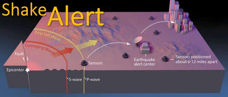
How it works
According to the USGS, the data collected through the GPS in a smartphone will be able to detect “permanent ground movement” associated with earthquakes.
By rapid processing of this information, the app will then be able to recognize an earthquake and promptly send out the alert.
Since the alert will travel at the speed of light, and earthquakes move closer to the speed of sound, the alerts can reach potential impact areas seconds before the shaking begins.
Warning vs. prediction
Melbourne makes it clear that this new app will not be able to predict earthquakes, saying that “prediction isn’t actually possible” and key factors must be considered when trying to predict an earthquake.
“You gotta say when, you gotta say where, and you gotta say how big,” Melbourne said. “[Prediction] is a hundred year old holy grail. It has never been solved, it never will be solved.”
While the development of this app is a new direction for the technology, according to Melbourne this is not the first early warning system created for earthquakes.
According to the USGS, Mexico first developed the technology after the 1985 Mexico City earthquake that reached a magnitude of 8.1. The resulting death toll was estimated at 10,153.
The USGS also said that Japan invested $600 million into their own system after the 1995 Kobe earthquake claimed the lives of 6,400 people. Turkey, Taiwan and China have all implemented similar systems as well.
However, the development of such systems tends to occur after an earthquake devastates a region, something geologists involved in this program are trying to prevent.
“We actually haven’t had a big earthquake in a metropolitan area in a hundred years in our country … but it is only a matter of time,” Melbourne said. “One way or another this system should be built.”
Funding
Though the USGS is spearheading the project, the initial funding for the program came from the Gordon and Betty Moore Foundation.
According to the Moore Foundation, their grants to the USGS, UC Berkeley, CalTech and UW have totaled nearly $6.5 million. However, Melbourne has said that the system is expected to cost nearly $200 million total.
Melbourne has also said that political debate has questioned whether government funding should be used to develop such a program. Counter arguments include spending the money elsewhere, such as on the improvement of freeway overpasses or public infrastructure.
Release date
Regardless of government financing for the project, the development of the app continues with beta testing proving successful in recent cases.
According to the LA Times, one achievement came in 2014 when scientists were given an 8 second warning prior to the 6.0 Napa earthquake that shook Southern California.
Public testing has since rolled out in California, and Berkeley has placed a timeline on the release of the ShakeAlert app. The goal is for the final product to be available through app stores within the next two years.