


Rattlesnake Ridge crack threatens Union Gap residents and highway
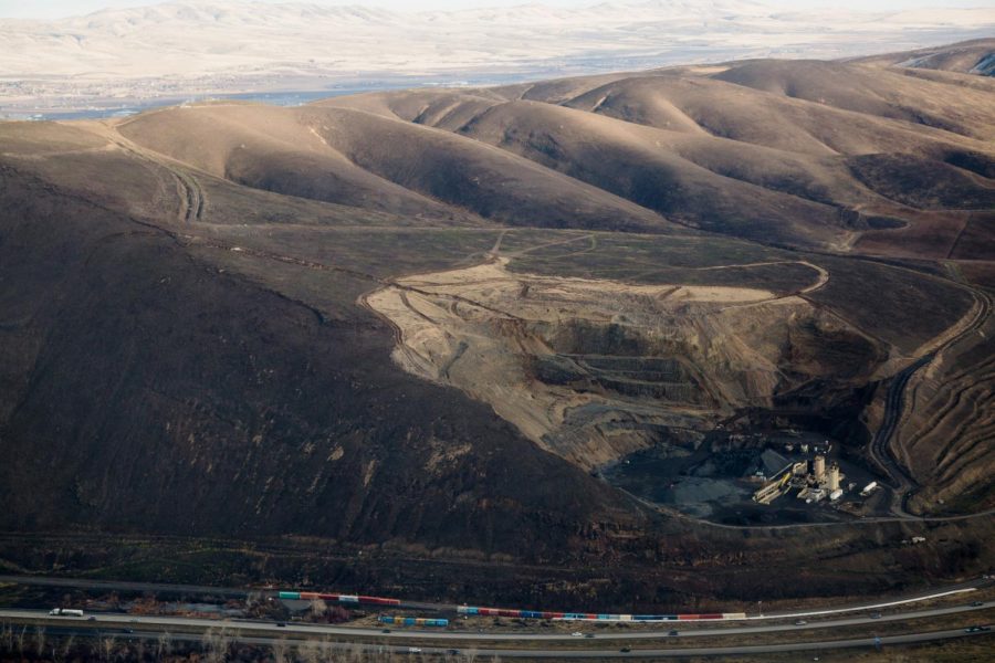
Aerial image of Rattlesnake Ridge, just south of Union Gap, Wash. on Wednesday, Jan. 10 2018. Courtesy of Shawn Gust / Yakima Herald-Republic.
January 19, 2018
Large cracks have developed in the Rattlesnake Hills near Union Gap also known as Rattlesnake Ridge, just south of Yakima, Washington, not to be confused with Rattlesnake Ledge or Ridge in North Bend, Washington. New cracks that were first noticed in October have increased in width and depth over the last few months.
A level three evacuation has been issued as of Dec. 29 for those living south of the cracks, according to the Washington State Department of Natural Resources (WSDNR) information page. Most evacuees have been provided temporary living situations and access to emergency services.
The land mass, estimated to be approximately four million cubic yards and covering 20 acres, according to the WSDNR information page, was expected to slide in late January or early February. But according to new data collected on site by Stephen Slaughter from the WSDNR, the slide is now expected closer to March due to the stop-and-go nature of the crack’s movement.
According to Slaughter, it is still unknown what caused the cracks to develop. WSDNR did not arrive at the site until October, at which point the focus of the department was to provide the best information to make the best decision, Slaughter said.
“The rates of movement in the last couple months have been alarming,” said Nick Zentner, a CWU geology professor. Zentner has been teaching at CWU for more than 20 years.
The land mass has been estimated to be moving at a rate of 1.6 feet per week, according to Slaughter, but the movement has been inconsistent, increasing then slowing down again for periods of time. The movement has increased in the last two weeks.
“It’s a complicated landslide, for sure,” Slaughter added.
The WSDNR is closely monitoring the slope with several instruments in place. The department has installed 65 GPS monuments and 22 reflectors and has been checking them every other day, according to Slaughter. WSDNR workers must walk out to these monuments and reflectors to measure movement, which can be dangerous considering the uncertainty of the slide.
“The key thing for us is safety,” Slaughter said.
The WSDNR is also utilizing other measuring instruments known as Total Stations, which can receive new data every 30 minutes using lasers. The stations are placed about 5,000 feet away and are much safer. They do not require workers to walk out onto the slope, which is a priority of WSDNR.
Perhaps the most high-tech instrument the WSDNR has used is Lidar. Only used on the western surface of the slope, Lidar is able to receive measurements of movement within inches. Using lasers, the Lidar compares data sets and recognizes the changes between scans. The WSDNR has already completed two Lidar scans and will receive another soon, according to Slaughter.
“It’s a complicated landslide, for sure.”
-Stephen Slaughter, Landslide Hazards Mapping Program Coordinator
Another agency monitoring the slide, the Washington State Department of Transportation (WSDOT), has detour routes in place in the event that rocks fall onto I-82. The WSDOT has placed large Conex containers along interstate-82, which are meant to catch falling rocks before they reach the highway. The WSDOT has also placed its own measuring instruments and is monitoring, according to Meagan Lott, a spokesperson for the WSDOT.
In comparison to the Oso landslide, another recent slide in Washington, Lott said the Rattlesnake Hills slide is much slower moving. The Oso landslide, occurring in March of 2014, covered about 40 homes and part of state route 530 in landslide debris and claimed 43 lives near Oso, Washington, according to the U.S. Geological Survey.
“It’s nothing compared to what [we saw] in the Oso landslide,” Lott said, referencing the speed at which the Oso slide collapsed.
According to Slaughter, the most likely outcome is the slide falling in a southern direction into a rock quarry. The company mining in the quarry, Columbia Asphalt, has terminated work and left the area as advised by the WSDNR.
Recreation and hiking in the area will remain undeterred. According to the Washington Trails Association, “it’s not impacting a trail system we have on our books.” However, there may be some unregistered trails around the quarry and in the hill surrounding it.